Partnering with Google Cloud to deliver impact
TraceMark is a 100% Google Cloud Platform solution that has been built on Google’s next generation geospatial technology including Earth Engine.
NGIS and Google Cloud have created TraceMark to deliver an enterprise approach to the sustainable sourcing of raw materials, designed to address corporate commitments to sustainability and to enable organisations to accelerate verification of sourcing activities to comply with deforestation free legislation.
TraceMark helps companies to accelerate their commitments to protect forests and the environment through responsible sourcing.

Google Cloud partner of sustainability award winner

NGIS awarded Google Cloud sustainability partner of the year
TraceMark is a 100% Google Cloud Platform solution that has been built on Google’s next generation geospatial technology including Earth Engine.
NGIS/TraceMark is extremely proud to be named the global Google Cloud Industry Solution Partner of the Year for the Sustainability category. The global award recognises our outstanding success in working with organisations to address their commitments to sustainability.
This award acknowledges NGIS has driven exceptional results with a large number of customers globally, through our Software as a Service (SaaS) TraceMark.
Partnering for sustainability
NGIS/ TraceMark has achieved the Google Cloud Ready - Sustainability designation in the Google Cloud Partner Advantage Program. By earning the sustainability designation, NGIS/ TraceMark has proven their success in building and producing solutions and tools on Google Cloud to help customers achieve their sustainability and Environmental, Social, Governance (ESG) goals.
Google Cloud Geo
Google provides the global leading geospatial cloud technology that is delivering next generation geospatial capability to organisations. The Google Cloud Platform provides unique geospatial capability that is designed to provide unlimited scalability and to enable enhanced value added applications of geospatial data and technology leveraging leading analytics and machine learning capability.
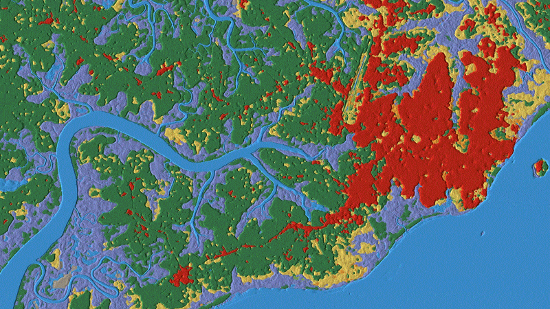
Dynamic World
A near realtime land cover dataset for our constantly changing planet
Dynamic World is a global near realtime 10m resolution global land use land cover dataset, produced using deep learning through a partnership between Google and the World Resources Institute. Over 5000 Dynamic World images are produced every day, whereas traditional approaches to building land cover data can take months or years to produce. As a result of leveraging a novel deep learning approach, based on Sentinel-2 Top of Atmosphere, Dynamic World offers global land cover updating every 2-5 days depending on location