Access global datasets for all your ESG requirements
TraceMark unlocks a massive data archive from Google Earth Engine and provides a central platform for combining customer data, Google delivered data and third-party data.
Over 80 petabytes of space based data is made available through TraceMark, updated daily. Industry leading satellite data from NASA, The European Space Agency, Google and Planet is integrated and attached to sourcing origins and supply chains. Third party data from certification bodies and leading global organisations are provided with ingestion patterns for commercial data from providers including UP42, Planet, Airbus, Maxar and Satellogic.
Our goal is to provide a consolidated platform for sustainability data, leveraging industry leading data products, continually expanding to include innovative new data products.

IBAT
The world's most authoritative biodiversity data for your world-shaping decisions
NGIS has established a partnership with IBAT to enable customers to leverage industry leading data as part of the TraceMark platform. Described by users as “a must for any project on biodiversity conservation”, IBAT provides authoritative geographic information about global biodiversity. It is underpinned by three of the world’s most authoritative global biodiversity datasets and enables users to make informed decisions in policy and practice.
IUCN red list of threatened species
The IUCN Red List of Threatened Species (also known as the IUCN Red List) is a rich compendium of information on threats, ecological requirements, and habitats of over 128,918 species; and on conservation actions that can be taken to reduce or prevent extinctions.
It is based on an objective system for assessing the risk of extinction of a species based on past, present, and projected threats. Species assessments are conducted following a standardized process using the rigorous IUCN Red List Categories and Criteria, ensuring the highest standards of scientific documentation, information management, expert review, and justification.
IUCN aims to re-evaluate the IUCN Red List category of species every five to ten years to monitor change.
World database on protected areas
The World Database on Protected Areas (WDPA) is a joint project between UN Environment Programme and the International Union for Conservation of Nature (IUCN), managed by UN Environment World Conservation Monitoring Centre.
Data for the WDPA is collected from international convention secretariats, governments, and collaborating NGOs. The WDPA uses the IUCN definition of a protected area as the main criteria for entries included in the database.
World database of key biodiversity areas
Key Biodiversity Areas (KBA) are 'sites contributing significantly to the global persistence of biodiversity’, in terrestrial, freshwater and marine ecosystems.
Sites qualify as global KBAs if they meet one or more of 11 criteria, clustered into five categories: threatened biodiversity; geographically restricted biodiversity; ecological integrity; biological processes; and, irreplaceability.
The World Database of Key Biodiversity Areas is managed by BirdLife International on behalf of the KBA Partnership.
The species threat abatement and restoration metric data layer
STAR scores for any terrestrial 5x5km grid cell provide an indication of the relative potential contribution to reducing species extinction risk through either threat abatement or restoration activities. STAR scores are derived based on a species’ current and restorable Area of Habitat (AOH). Terrestrial scores are currently calculated for species of amphibians, birds and mammals for which current or historical AOH are available.
Rarity-weighted species richness
The rarity-weighted richness map is a raster layer showing the relative importance of each ~10km (30 arc-seconds) grid cell in terms of its aggregate contribution to the global distribution of species of mammals, birds, amphibians, crabs, crayfishes and shrimps. High values show that a cell holds a large number of species and/or that the average ranges of the species present in the cell are small, so that the cell represents a relatively high proportion of their range. Rarity-weighted richness is also known as ‘range-size rarity’ or ‘range-rarity’, and has been used as a metric of ‘biodiversity significance', as well as feeding into the Biodiversity Impact Metric.
Dynamic World
A near real-time land cover dataset for our constantly changing planet
Dynamic World is a global near realtime 10m resolution global land use land cover dataset, produced using deep learning through a partnership between Google and the World Resources Institute. Over 5000 Dynamic World images are produced every day, whereas traditional approaches to building land cover data can take months or years to produce. As a result of leveraging a novel deep learning approach, based on Sentinel-2 Top of Atmosphere, Dynamic World offers global land cover updating every 2-5 days depending on location
-
![]()
Supply Chain
Tracking supply chains allows businesses to gather all information from when the product is a raw material to its finished item.
-
![]()
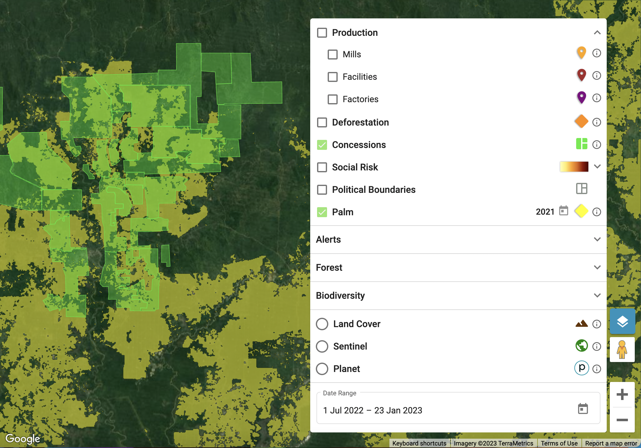
Concessions, Estates and Farms
Concessions, Estates and Farms
-
![]()
Commodity Masks
TraceMark provides commodity masks for the detection of different raw materials from space including palm and soy.
-
![]()
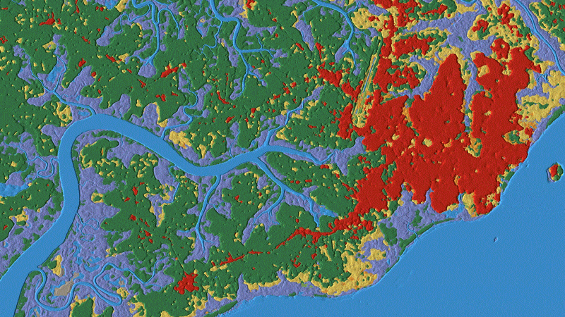
Forest Datasets
Forest datasets gives you access to the latest forest data such as forest cover, high carbon stock and canopy height.
-
![]()
Deforestaion
Track deforestation with industry leading and verified data products both inside sourcing footprints and across sourcing origins extending from the year 2000
-
![]()
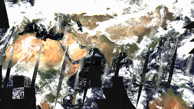
Satellite Imagery
Daily satellite imagery for analysis and inspection from a number of leading global providers including patterns for integrating additional commercial imagery.
-
![]()
Alerts
Near real time global alerts for fires and deforestation including TraceMark designed integrated alerts to reduce false positive detection and deliver higher confidence.